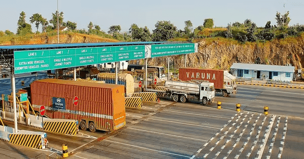
The new GPS-based toll collection system, which will gradually replace the physical booth system and FASTag, will likely launch by the end of April 2025. The government is launching this to eliminate congestion and charge a fair toll based on the distance.
Now, the highway travellers will only pay for the actual stretch they use, unlike the fixed amount that the FASTag system charged. The Minister of Road Transport and Highways, Nitin Gadkari, positively said that the new toll collection system will likely roll out within the next 15 days.
What is satellite-based toll, and its implementation progress?
GNSS (Global Navigation Satellite System) works like the GPS on mobile phones, and the government will use this technology for collecting tolls on highways. A vehicle will have a small tracker (On-board unit or OBU) that can talk to the GNSS satellites.
People won't have to stop and pay toll plazas as the tracker calculates the distance between the entry and exit points on the tolled highway and accordingly charges the driver at a specific rate.
The Ministry of Road Transport and Highways (MoRTH) is testing this new method in Haryana and Karnataka on the Panipat-Hisar and Bengaluru-Mysore national highways. Its implementation is going to be phased, and the commercial vehicles are being tested before the private ones.
The new satellite-based toll system will work in hybrid mode with the FASTag collection and will soon transform into plaza-less entries. The union minister has declared that the GNSS-based toll collection system will launch by May 1, 2025.
Also read: MG Windsor Becomes Fastest Selling EV with 20K Units in 6 Months
Why is the government replacing FASTag with a GNSS-based toll?
The new GPS-based toll collection system will replace physical toll plazas with virtual gantries that track vehicles and deduct tolls automatically. Here are the core reasons the MoRTH is changing it:
- To reduce traffic congestion and waiting times
- To ensure fair, distance-based toll pricing
- To eliminate corruption at the toll plazas
- To make the nation's toll collection more tech advanced
- To utilize the new system for potential value-added services like smart traffic management
How does this new toll collection system work?
The highway authority is going to use a Toll Charger Software for the GNSS-based Electronic Toll Collection (ETC) system. This program tracks the vehicle's highway journey using GPS or GEO Augmented Navigation (GAGAN) technology. Here are the main steps in the working of this new system:
- The vehicle gets a digital tracker
- Satellites track the vehicle journey
- Virtual toll booths replace physical toll plazas
- Distance-based toll payment starts (per km)
- Automatic deduction linked wallet or account